I discovered an out-of-print Moorumbine Heritage Trail brochure, which led to a wealth of information in the book ‘Pingelly Our People and Progress’ by Sylvia Lange (Ref 1). This blog is a brief digital summary of Moorumbine history for visitors and hopefully, will stimulate more information on the fascinating early history and people in the district to emerge.
The Moorumbine Heritage Trail brochure has been recreated in this blog.
The Moorumbine Heritage Trail brochure has been recreated in this blog.
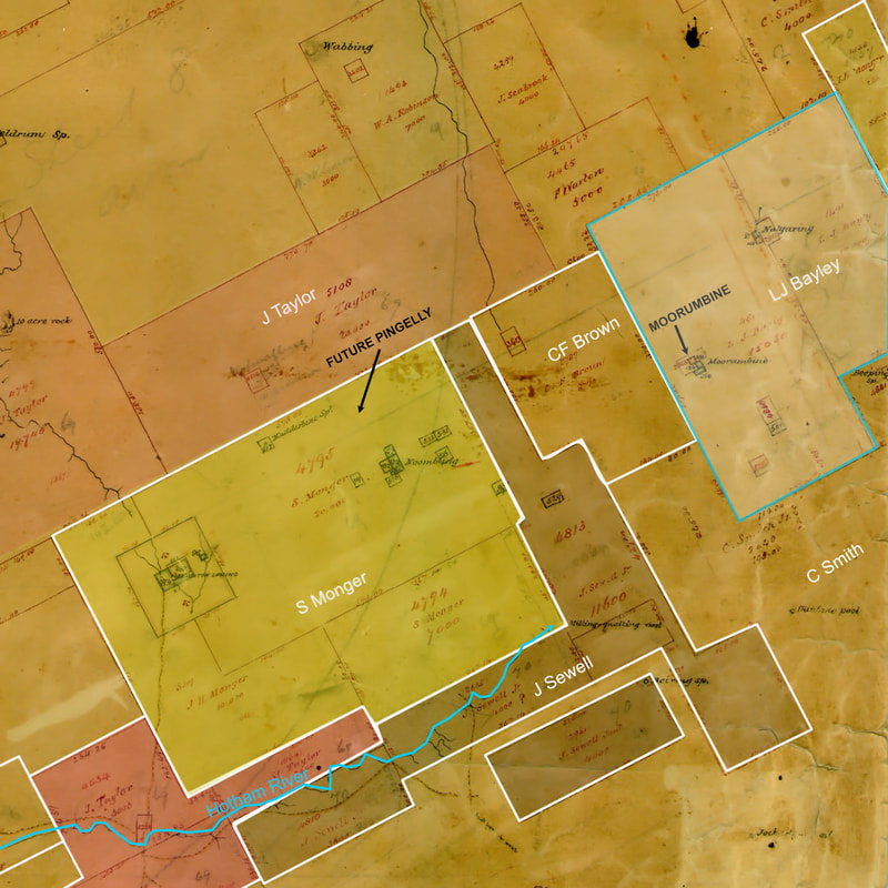 Early map showing grazing leases
 Moorumbine (also spelt Mourambine is located 10km east of Pingelly
It is the first surveyed township in the Central Great Southern district and was a key stopping point from York to the north, Williams to the south-west and for pioneers and sandalwood cutters, who ventured far inland, until the Great Southern Railway line was constructed in 1889.
First white settlers in the district were graziers who purchased small annual ‘tillage leases’ at local waterholes, which were used as a base for sheep grazing on large grazing leases on native pastures.
Lewis John Bayley was the first settler to take up land in the Moorumbine area. In 1846 he was granted 4000 acres (1620 ha) for grazing sheep near a spring called Nalyaring by local Nyoongars. He was followed by other pastoralists keen on obtaining grazing lands for sheep. Individual flocks were tended by up to four shepherds. Initially there was very little farming conducted.
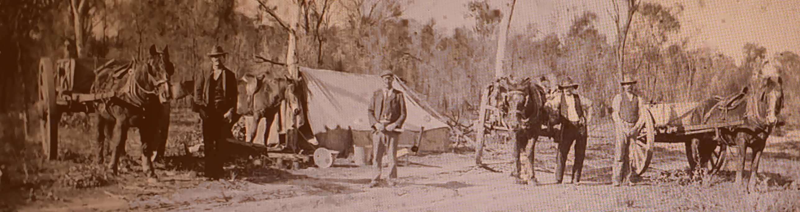
In 1845 an important trade in sandalwood was commenced with Singapore and Shanghai, which led to a sandalwood collecting boom. Principally young men would take wagons out into the bush to pull out sandalwood trees and prepare the wood for export. Sandalwood collecting was also done by later arriving farmers, who had to obtain income by any means to survive while they were clearing and preparing their land for cropping. They also trapped possums for their skins and hunted kangaroos for meat. From 1900 brown mallet bark was also collected for export, mainly to Germany for tanning leather.
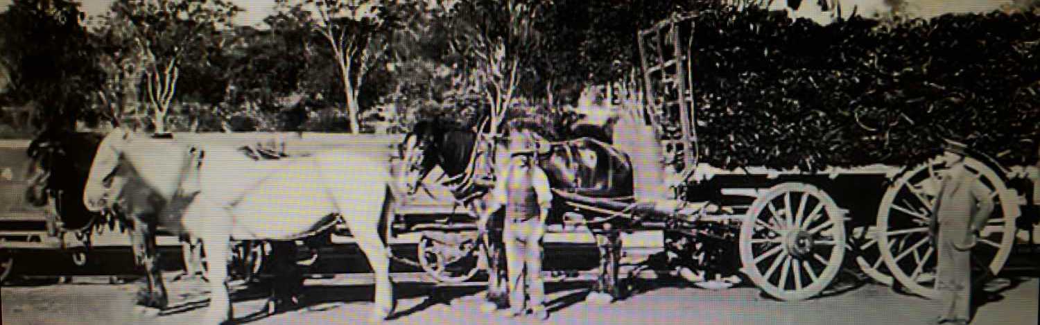
The type of wagon used for carting sandalwood (in this case the load is mallet bark) Image from Lost Pingelly Facebook
Gradually more permanent settlers arrived in the district, and the fine buildings to be seen on the Moorumbine Heritage Trail were constructed.
These were all built on 100 acre freehold blocks on water sources. The area was first surveyed by Frances John Gregory in 1856 and Richard Austin in 1858.
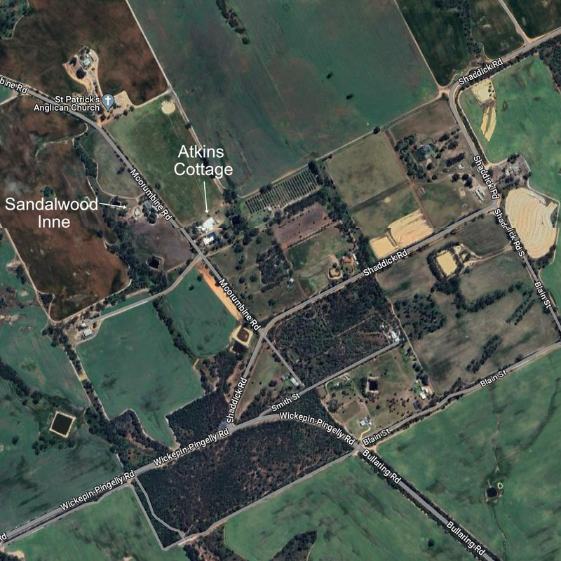
A permanent settlement was established in about 1860. Among the first permanent settlers were William Shaddick, William Ingram and Charles Chapman Smith.
The settlement was initially divided into 100-acre homestead blocks and called Moorumbine Commonage (a reflection of their English country heritage).
Moorumbine Road was originally a track to Beverley called “the Old Beverley Road” until it reached the township as a laneway known as “The Mourambine Lane” . Only half a chain wide, this is the ‘Half Chain Road shown on the Moorumbine Heritage Trail. Convicts were marched along this road to do public works, and barred windows on some Moorumbine buildings indicate that they were used as convict holding cells when required.
These were all built on 100 acre freehold blocks on water sources. The area was first surveyed by Frances John Gregory in 1856 and Richard Austin in 1858.
A permanent settlement was established in about 1860. Among the first permanent settlers were William Shaddick, William Ingram and Charles Chapman Smith.
The settlement was initially divided into 100-acre homestead blocks and called Moorumbine Commonage (a reflection of their English country heritage).
Moorumbine Road was originally a track to Beverley called “the Old Beverley Road” until it reached the township as a laneway known as “The Mourambine Lane” . Only half a chain wide, this is the ‘Half Chain Road shown on the Moorumbine Heritage Trail. Convicts were marched along this road to do public works, and barred windows on some Moorumbine buildings indicate that they were used as convict holding cells when required.
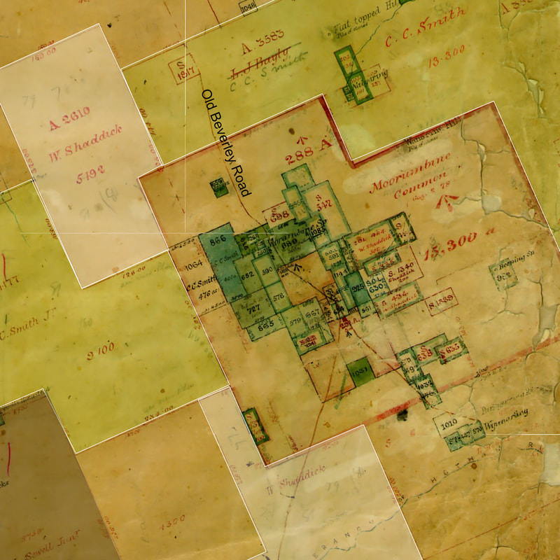
Moorumbine Commonage plan
|
All inhabitants black or white gathered at the common for periodic ‘race meetings'. Apparently, the main idea was to get there as soon as possible, get as drunk as possible and have at least one fight before the race ended. There were no entry fees no bookies and probably no prizes for the winners. Any horse, be he a racer, Clydesdale, draught or otherwise, entered the events. One amusing incident is related regarding a horse from which the bell could not be removed. All frantic efforts to do so proved unsuccessful - so with the full spirit of the time, he raced, bell and all! Ref 1 |
| Life was very tough in those days, particularly for women. Men outnumbered women considerably in a frontier society with the most basic housing, no facilities, lots of alcohol and a monotonous diet of tinned and ‘bush' meat. Vitamin deficiency due to a lack of fruit and vegetables caused health problems such as Barcoo skin sores. | 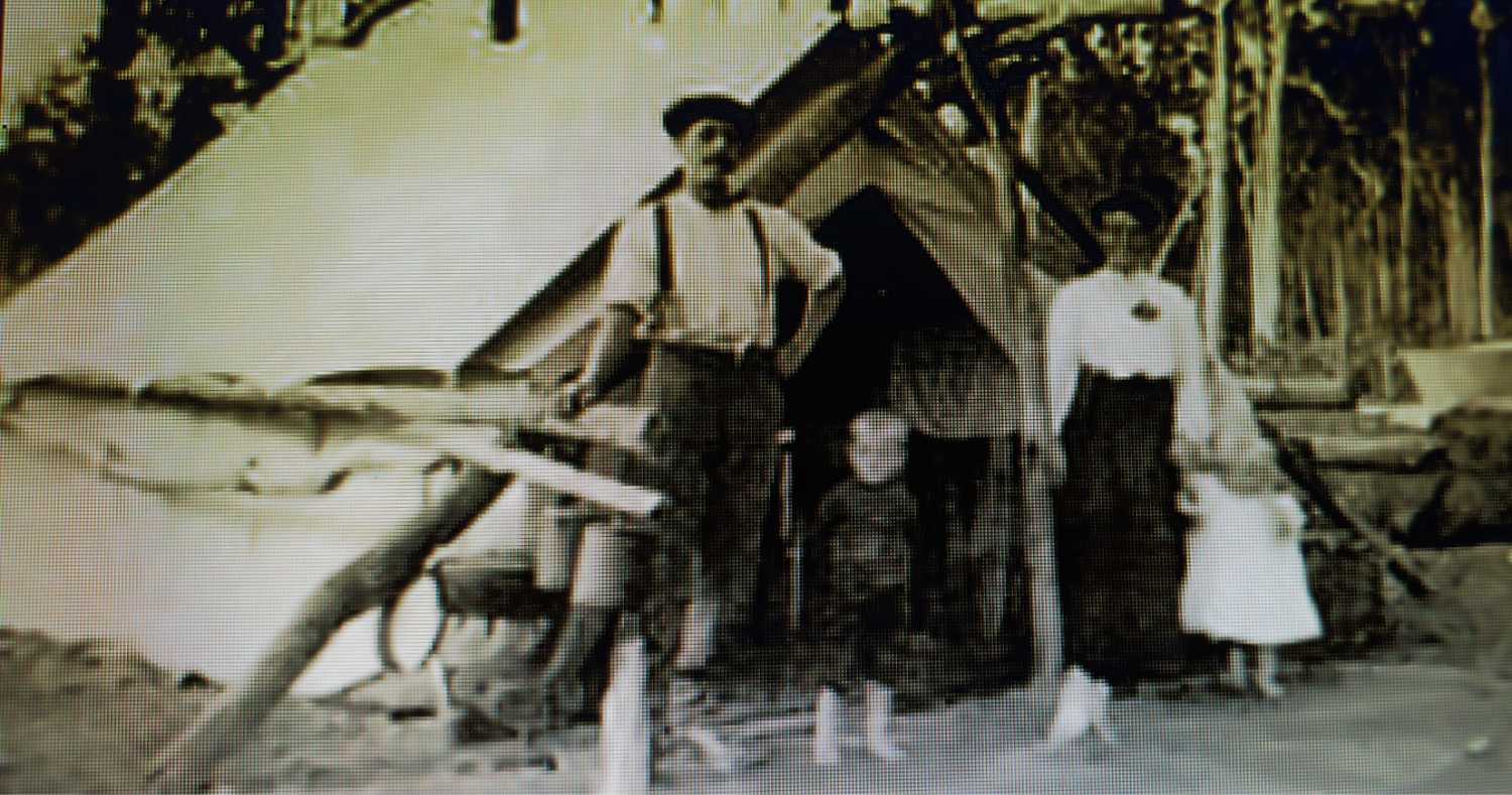 |
‘Disease of the liver,...... is extremely rare considering the amount of alcohol consumed. Ref 2
........taking into consideration the habits of many of the residents I have been astonished at the apparent immunity from disease they enjoyed and accounted for it only from the fact that they were living in a primitive atmosphere and in a settlement free from any of the ordinary external exciting causes of disease also that their occupations were active and their circumstances of life were generally such as to counteract the injurious tendencies of their special habits the sun in Western Australia being as a general rule free from those debilitating effects which usually characterise solar heat elsewhere......
WA military Surgeon General's report 1860
WA military Surgeon General's report 1860
Surveyors' camp source Lost Pingelly Facebook
As with other reported first contacts, Nyoongars were friendly and helpful in assisting Moorumbine visitors to find sandalwood and water sources, which they regarded as shared resources. Unfortunately, a clash of values became obvious when settler’s sheep were occasionally speared. Some Nyoongars worked as shepherds and worked on farms, particularly after mass deaths from devastating disease outbreaks in the 1880’s disrupted their society.
Official opinion of aborigines at this time is reflected in this quote from an 1860 History of WA, which ignores recorded incidences of conflict.
Official opinion of aborigines at this time is reflected in this quote from an 1860 History of WA, which ignores recorded incidences of conflict.
The native inhabitants are superior to those of the other colonies in Australia this is attributed to the personal character and conduct of the earliest settlers of whom an unusual proportion belonged to the better classes of society. The settlers are reaping the well merited fruits in the perfect tranquillity they enjoy and the assistance received from the coloured people. They are employed as herdsmen and messengers and will work at reaping and harvest work but will in no case continue at hard work or remain longer than they please. The bush life to them has irresistible charms and although children have been in some cases educated and trained in the hope that they might be rendered permanent settlers yet on the attainment of maturity all the lessons of the past are disregarded and the intelligent child becomes the lazy dirty wandering animal gorging himself to stupidity and utterly disregarding any provision for the future.
The growth of “Mourambine" itself continued so that on 24th April 1884 it was declared a townsite. No doubt rumours about
the construction of the “Beverley-Albany“ railway brought about this decision. Between 1884 and 1885 twenty-one town lots were sold, indicating faith in the future of the township.
the construction of the “Beverley-Albany“ railway brought about this decision. Between 1884 and 1885 twenty-one town lots were sold, indicating faith in the future of the township.
 Moorumbine 2024 | 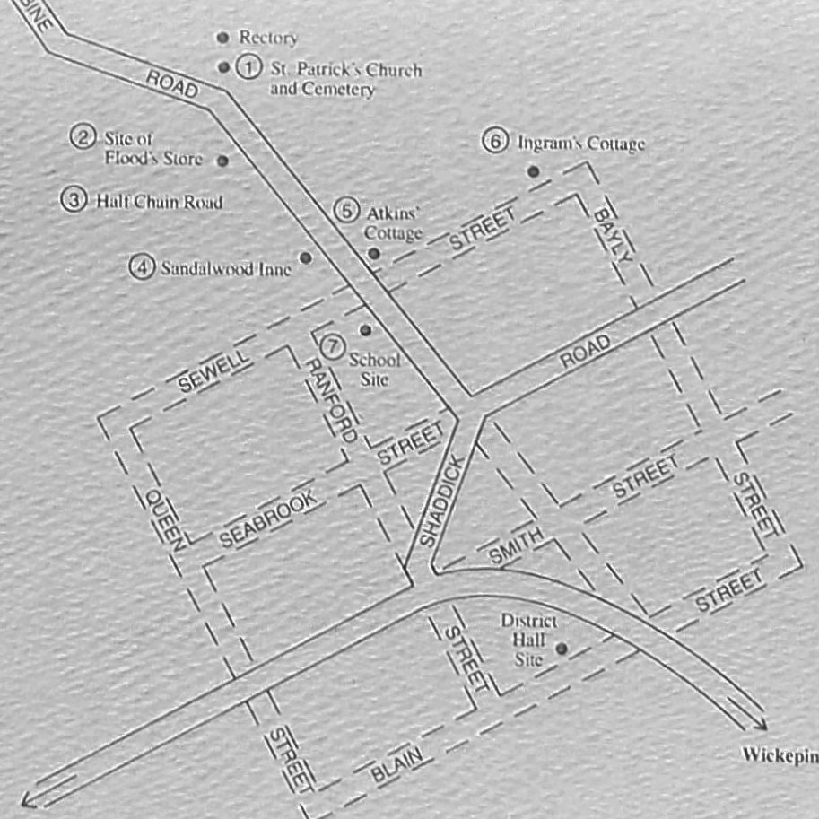 1884 Moorumbine townsite |
However the railway line was surveyed through Pingelly 10 km to the west
One would have thought the people of Moorumbine would have fought to bring the railway through their village, but there is no record of this. Perhaps they preferred their peaceful existence.
The railway marked the rise of Pingelly and the gradual decline of Moorumbine.
In the 1897 census, the population was: Moorumbine 80 males, 81 females, 161; Pingelly 52 males, 37 females, 89. Moorumbine today has only a few remaining families and the Moorumbine Heritage Trail buildings.
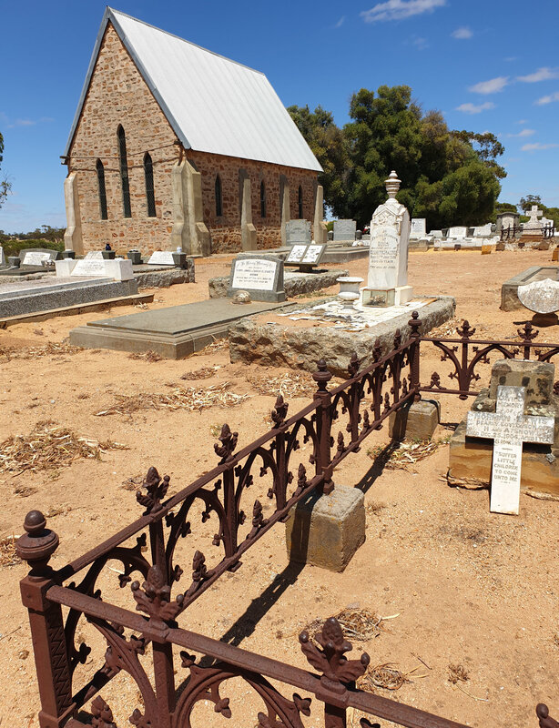
St. Patricks Anglican Church is in excellent condition and is still used for the occasional service.
References
One would have thought the people of Moorumbine would have fought to bring the railway through their village, but there is no record of this. Perhaps they preferred their peaceful existence.
The railway marked the rise of Pingelly and the gradual decline of Moorumbine.
In the 1897 census, the population was: Moorumbine 80 males, 81 females, 161; Pingelly 52 males, 37 females, 89. Moorumbine today has only a few remaining families and the Moorumbine Heritage Trail buildings.
St. Patricks Anglican Church is in excellent condition and is still used for the occasional service.
References
- Pingelly Our People and Progress. 1981 Sylvia Lange
- The York Society Inc
- Taylor, Thomas George (1860). Western Australia; its history, progress, position, & prospects, Volume 13
- Lost Pingelly Facebook
- The pioneers of Mourambine, including "a brief history of the townsite, 1842-1924" / researched and written by Lesley A. Lane and Florence C. Wilkes is a book, (which I haven't read) that is kept at the WA State Library .