|
This is a short drive trail, which features historic locations in the Moorumbine town site. There are seven stops with information panels, which are all on Moorumbine Road. More Moorumbine history information is contained in this blog.
Moorumbine (also spelt Mourambine) is located 10km east of Pingelly It is the first surveyed township in the Central Great Southern district and was a key stopping point from York to the north, Williams to the south-west and for pioneers and sandalwood cutters, who ventured far inland, until the Great Southern Railway line was constructed in 1889. After this the town declined. |
|
1. School site
Two buildings occupied this empty site. The first, built by settlers was a typical wooden building with a thatch roof made with grass tree (balga) leaves. in 1887 this was replaced by a handsome brick building with a shingle roof.
Attendances at the one-teacher school averaged between Ю and 40 until 1908. after which they' declined.
Parents paid five pence (four cents) per week tuition fee.
The school closed in 1913, opened again in 1917, but closed for the last time in 1924 due to insufficient numbers. The bricks were later used for the construction of a building in Pingelly.
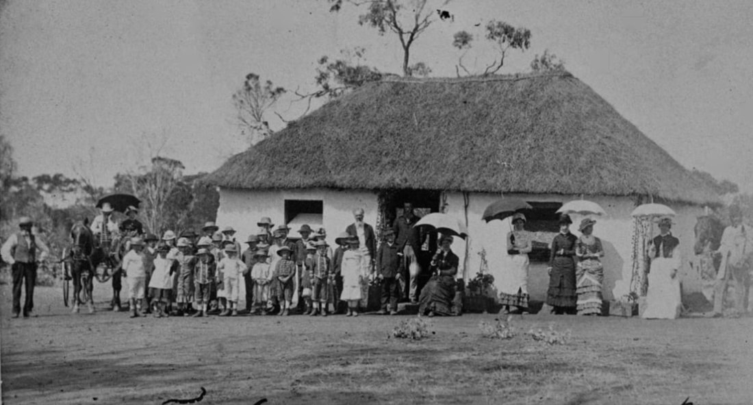 First Moorumbine school (courtesy SLWA) | 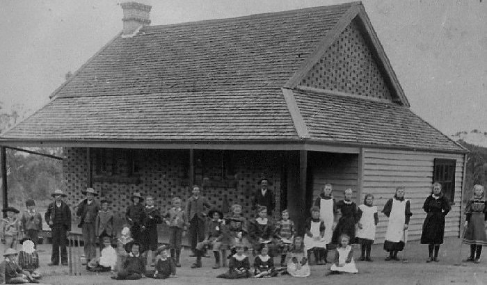 Second Moorumbine school (courtesy SLWA) |
2. Ingram's Cottage This house is on private property. Please view from the road.
William Ingram built this cottage in 1889 using hand-made bricks fired on site. Bush timber was used for the roof and floors. Ingram was one of the first permanent settlers in the district and was granted a 100 acre (40.5 hectare) homestead block in Moorumbine in 1863. He and his wife Mary had arrived from Denton, England earlier that year after enduring seven months at sea. They initially built a small mud brick dwelling, the remains of which can still be seen in the middle of the property. After building his new home, Ingram used the mud brick dwelling as a stable and also a blacksmith shop. It is thought that at one time it may have been used as a holding cell for prisoners being transported between Perth and Albany. Note bars on windows. Ingram worked for a while with Atkins and together they built nearly all the stone buildings in Moorambine. He and Mary lived here with their child Eliza until their deaths. Mary in 1918 aged 79, and William in1926 aged 87. The pear tree in the cottage was planted by Ingram in the mid 1880’s.
William Ingram built this cottage in 1889 using hand-made bricks fired on site. Bush timber was used for the roof and floors. Ingram was one of the first permanent settlers in the district and was granted a 100 acre (40.5 hectare) homestead block in Moorumbine in 1863. He and his wife Mary had arrived from Denton, England earlier that year after enduring seven months at sea. They initially built a small mud brick dwelling, the remains of which can still be seen in the middle of the property. After building his new home, Ingram used the mud brick dwelling as a stable and also a blacksmith shop. It is thought that at one time it may have been used as a holding cell for prisoners being transported between Perth and Albany. Note bars on windows. Ingram worked for a while with Atkins and together they built nearly all the stone buildings in Moorambine. He and Mary lived here with their child Eliza until their deaths. Mary in 1918 aged 79, and William in1926 aged 87. The pear tree in the cottage was planted by Ingram in the mid 1880’s.
3. Atkins's Cottage (Moorumbine Cottage)
This cottage was built in 1872 by carpenter and stonemason William Atkins, who also built St Patrick's Church. That year he and his wife Mary were the first couple to be married at the church, before it was consecrated. They moved into the two-room house and raised 7 or 8 children there. Additional rooms were added later. Underneath the house is a very large cellar that was used for food and drink. The cellar was prone to flooding and Mrs Atkins spent many hours bucketing out water on wet winter days. On the property beyond the house is a large olive tree said to have been planted by Benedictine monks from New Norcia when they passed through the district around 1873
This cottage was built in 1872 by carpenter and stonemason William Atkins, who also built St Patrick's Church. That year he and his wife Mary were the first couple to be married at the church, before it was consecrated. They moved into the two-room house and raised 7 or 8 children there. Additional rooms were added later. Underneath the house is a very large cellar that was used for food and drink. The cellar was prone to flooding and Mrs Atkins spent many hours bucketing out water on wet winter days. On the property beyond the house is a large olive tree said to have been planted by Benedictine monks from New Norcia when they passed through the district around 1873
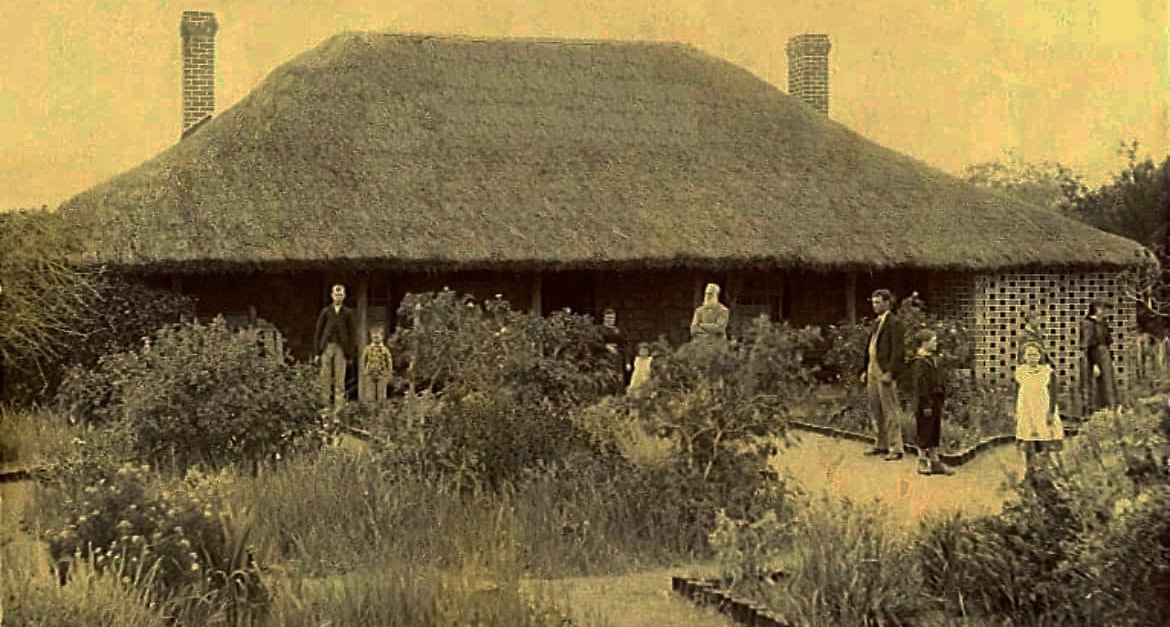
Atkins Cottage 1889 (courtesy SLWA)
4. Sandalwood Inne
The house was built in 1872 for Samuel Wright a Beverley farmer and sandalwood cutter. The land was owned by John Sewell a sheep farmer who sold part of it to Wright in 1882, and the adjoining section to William Atkins in1884
The history of the building is unclear but it appears to have been used for several purposes including an inn and possibly a post office. Charles Chapman Smith and his brother Henry Hawkins Sewell are recorded as using the building as a store in 1876 and their as a hotel in 1882 selling rum. It is believed he possessed a ‘gallon licence" which restricted him to selling liquor in quantities not less than a gallon (4.5 litres) at any one time !!!
Note the bars in the window on the north side of the building. This room was possibly used at one time as a holding cell for prisoners and convicts.
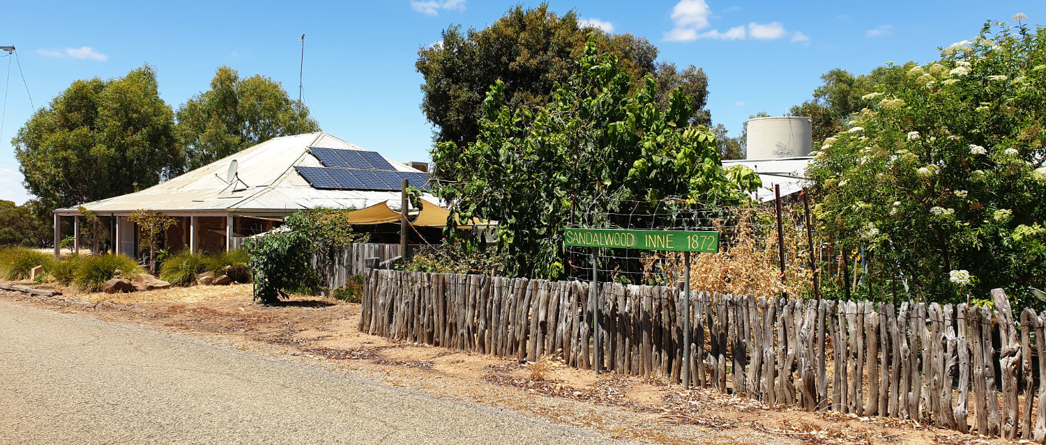
Sandalwood Inne 2024
5. Half-chain Road This is the road that you are driving on.
In the early years of settlement the Old Beverley Road (then a rough dirt track) passed through Moorumbine and on to Albany. Convicts and prisoners were often marched through the town along this road. In Moorumbine the road reserve called Moorumbine lane was only half a chain 10 metres wide half the width of most roads. Main buildings and the established part of town was on either side of the road.
In the early years of settlement the Old Beverley Road (then a rough dirt track) passed through Moorumbine and on to Albany. Convicts and prisoners were often marched through the town along this road. In Moorumbine the road reserve called Moorumbine lane was only half a chain 10 metres wide half the width of most roads. Main buildings and the established part of town was on either side of the road.
6. Site of Flood's Store North end of paddock opposite the church
This pile of rubbish is all that remains of a general store run by a Mr Flood that was built around 1884. Parker Shaddick grandson of early settler William Shaddick recalled that he bought lollies there on special occasions.
The store was only run for a few years it seems and after a few years that the railway was completed in 1889 it moved to Pingelly
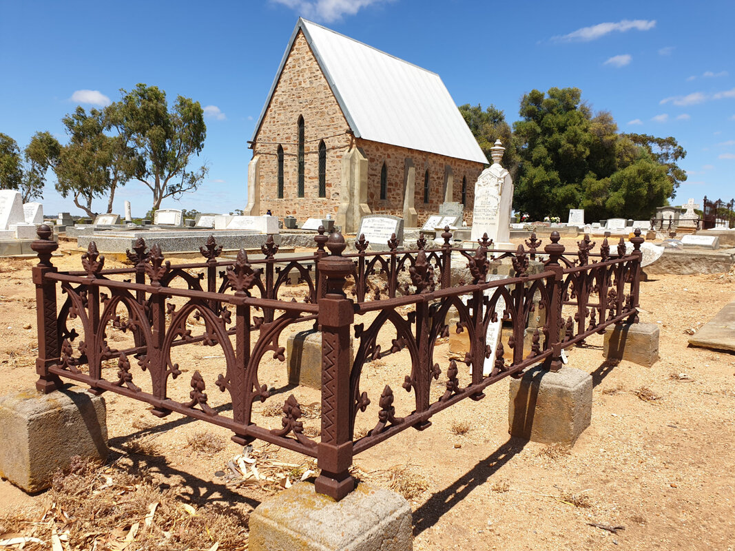
7 St Patrick’s Church of England
This is a scenic church, flanked by olive trees and a graveyard where leading settlers and their family rest.
Seats of the church were made at the “Establishment” as it was then known, or in other words, by convict labour in York. Each family held a special pew for which “Pew Rents” were regularly paid.
Occasional services are still held here.
|
But for a fluke of fate this fine stone church would not exist. |
The stone church was completed in 1872 and consecrated in December 1873 by Bishop Hale, Western Australia’s first Anglican bishop. At first there was no resident minister and communion was taken here only twice a year by a minister from Beverley. Two lay people took services on a regular basis until 1892 when the Rev FC Gillett was appointed to look after the newly formed parish of Moorumbine which included another 11 churches.
Rev. Gillett stayed away in distant places such as the Bannister Parsonage while ministering to his extended parish.
The nearby rectory (not open to the public) was built at this time and was allotted to Rev Gillet for the length of his lifetime. After his death in 1904 it was decided to grant ownership of the rectory to descendants of Rev. Gillett. His position remained vacant after his death, as by this time, Pingelly had become the main economic and cultural centre of the district.
This completes the Moorumbine trail. Trail users can return north along Moorumbine road. About 200 metres past St Patrick’s church on the left is the former property of Charles Chapman Smith one of the first permanent settlers in Moorumbine who arrived in about 1860. It is known as ‘Beambine today and is still being farmed by his descendents.
A little further on the right a few rocks and timber poles are all that remains of the stables owned by William and Faith Shaddick who settled in the 1860’s. Their house built nearby was known as the ‘old Moorumbine’, possibly due to the old spring just across the road. The home has long disappeared. The stables are also believed to have been used as a shearing shed.
To continue to Pingelly turn left at Aldersyde road.