Foxes Lair
  • Home
  • About
    • About Foxes Lair
    • History
    • Landscape and Soils
  • Things To Do
    • Picnic Spots
    • Walk Trails
    • Visit the Arboretum
    • Ride Your Bicycle
    • Scavenger hunt
    • Geocaching and Orienteering
  • Things To See
    • Wildflowers
    • Trees in the Narrogin district
    • Birds
    • Vertebrates
    • Narrogin spiders scorpions ticks
    • Fungi and lichens
  • Foxes Lair seasonal guide
    • December to March
    • April - May
    • June-July
    • August
    • September
    • October
    • November
  • Other great reserves
    • Railway Dam
    • Yilliminning Rock
    • Old Mill Dam
    • Yornaning Dam
    • Contine Hill
    • Highbury Reserve
    • Boyagin Rock
    • Barna Mia
    • Toolibin Lake
    • Newman Block
    • Harrismith Nature Reserve
    • Candy Block
    • Tutanning Nature Reserve
  • 1Foxypress
    • Foxypress
    • Vanishing Farms
  • Contact

Marri Picnic Area Foxes Lair

14/2/2019

0 Comments

 
​Greetings fellow Foxies,
                                     When the Friends of Foxes Lair group formed in 1999, Foxes Lair was much neglected. Numerous tracks were used as a rally circuit for trail bikes, 4WD and other vehicles, and it was used for dumping rubbish, and fireside drinking parties.
The group developed a management plan and got to work. A few years later when 30 years of regrowth was cut out to restore the arboretum, I realised that we had no before and after photos to record the tremendous progress that we had made.
I have set up a reference sites throughout Foxes Lair that are photographed regularly.
Progress over the years has been 2 steps forward and one step back.
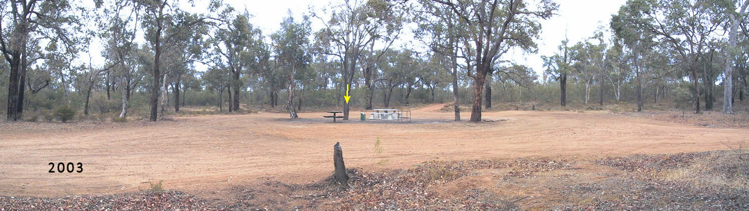
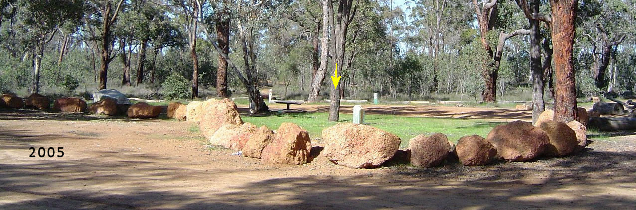
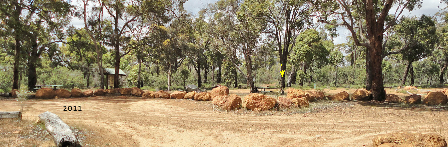
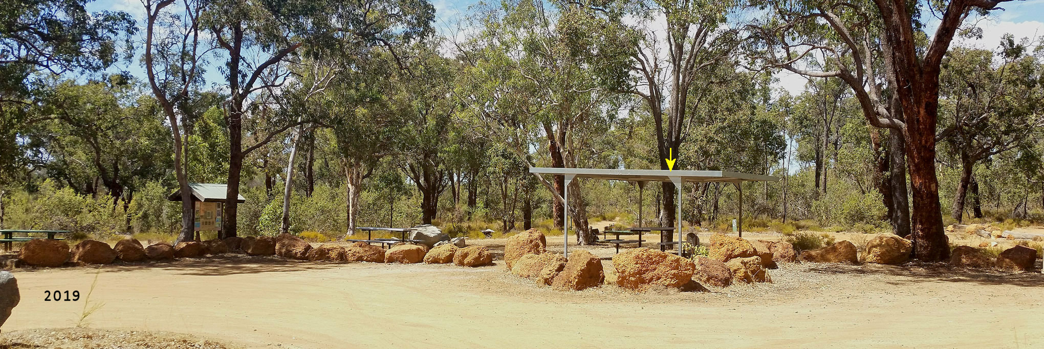
Despite this, images of the Marri picnic area below indicate significant progress. The yellow arrow shows the same tree in each image.
In 2003 the picnic area was an evening speedway circle with spectators in the centre. Roads radiated out in four directions. The concrete picnic table was then destroyed by someone using a sledge hammer.
Picture
​With shire assistance we designed and built a car park using boulders and telephone pole bases to separate vehicles from the picnic area and used converted roads into the three walking trails. One night a group used the poles for a bonfire (and got a good dose of arsenic from the wood preservative).
Picture
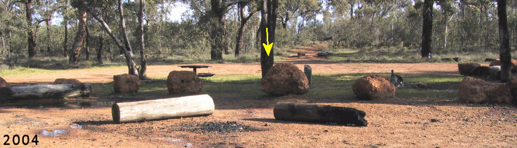
​More boulders were brought in to create the barrier that you see now. 
Picture
​In 2010 we obtained a Lotteries Commission grant for an information bay and a new picnic table (far left) 
Picture
​In recent years Narrogin Shire has installed two new picnic tables (one under cover)
Picture
​The Narrogin shire is in the final stage of producing a trails master plan, which will provide a blueprint for future upgrades to Foxes Lair trails. A long overdue replacement map poster should be in place by June.
0 Comments

EAST YORNANING NATURE RESERVE

11/2/2019

0 Comments

 
Picture
​Greetings fellow Foxies,
                                     This reserve is an absolute gem, which is actually a long way east of the Yornaning siding. It is 20km north-east of Cuballing in the Wickepin Shire. To get there from the Great Southern Highway, turn east at Cuballing on the Cuballing East Road, Turn left up Pauley Road, drive past Commodine Reserve, to the start of the reserve at the Modra Road turnoff.
​​We have variable soil types, First World War, the Great Depression, and the rabbit plague to thank for this reserve. As early lithographs on left show, the reserve was allocated for farming, starting from the early 1900s when there were plans for an east/west railway line through Cuballing, with Wickepin Springs in red as a proposed townsite.

Picture
Most of the reserve was cleared but regrew after the owner went broke and walked off the property. As it contains lots of rocky and poor sand areas, the land was resurveyed as a reserve.
 
This reserve is a part of the catchment divide between the Hotham, and Avon river catchments.
This reserve has a great mix of rocky soils, sandplain, breakaways and pristine forest types, which change frequently revealing new flowers and views as you wander through the bush.
One downside is that the tracks are not frequently maintained. Many are a bit rough and stony (OK for my ute), and have two sandy areas that an average car could get bogged when dry.
The reserve has upland pale sand/ sandy gravel plains that are often bounded by steep breakaways (red dotted lines). The bulk of the reserve is undulating sheoak and wandoo soil with rock outcrops (great spring wildflower country).
Arrows show suggested driving direction for average cars. Double arrows indicate that you can drive in either direction. Where tracks pass through loose sandy spots the single arrow indicates driving in a downslope direction, and to avoid stopping in loose sand. Avoid driving in the south-east corner – you may get stuck in boggy spots and below a very steep slope.

Picture
​The shaded zones below are my favourite spots
Picture
Picture
Zone 1 is granite outcrop with sheoak/wandoo gravel woodland bounded by a steep breakaway on the west.
 To get there drive on to the firebreak on the eastern side of the reserve and follow it all the way to a granite outcrop, and turn around and return the way you came.The trail continues over the granite outcrop but please do not drive on it. The trail is rocky and rough and leads to a very steep breakaway that is only suitable for 4WD vehicles.
This is lovely wildflower country in spring and a nice place for a picnic.
However be on your guard! I found a fearsome claw there that could only belong to an East Yornaning Bunyip.

Picture
Picture
Picture
if you only have a 2WD vehicle  the easiest way to visit it is to drive on to the firebreak on the eastern side of the reserve, turn right on the second intersecting track, park on firm soil at the start of the sand and walk uphill. If you wish to drive through this area with a 2WD, approach from the south, either from the track leading off Modra Road, or the (zone 3) first intersecting track along the eastern firebreak.
On the original block description this area was called ‘Worthless Sand’. Thank heavens it wasn’t ever cleared, as it has the most diverse collection of white sand wildflowers that I have seen in the district. It is a kwongan shrub plain containing scattered Banksia attentuata and Christmas tree/Nuytsia floribunda trees. You need to visit his area at least four times to catch the overlapping peak flowering periods: Late August, October, November, and December-January. Fabulous area!
A small fenced area at the top of the slope protects a rare Acacia. It also contains other species that are not growing outside, and shows that isolated reserves are not necessarily ‘natural’ due to kangaroo grazing pressure and other stresses.

Picture
Picture
Picture
​To get to zone 3 drive along the firebreak on the eastern side of the reserve and turn right on the first intersecting track. The track is quite firm but can be a bit rough and stony in sections. A good place to stop is about 100 metres before meeting an intersecting track on the right (Avoid driving through the track on the right as it contains a very loose sandy patch). This zone has wonderful open bushwalking country, great sheoak/wandoo everlasting displays and brown mallet breakaways. Good reception on my Telstra smartphone enables me to keep my bearings.
Surprisingly this reserve is not a great orchid spot. I saw Enamel, Fringed Mantis, Cowslip, Blue Fairy, Greenhood, snail Greenhood, and Jug orchids and hope to find the Leafless Orchid spot next season

Picture

​Definitely visit this reserve if you enjoy bushwalking, bird watching and wildflower displays, and your car can handle bush tracks (2WD fine if you are careful).
Do not visit if you are car proud and need well developed and signposted walk trails
For visual exploration of the reserve click this link
0 Comments

How Natural is our Bush?

9/2/2019

0 Comments

 
Greetings fellow Foxies,
Local history accounts and observations in many reserves have made me realise that our so-called ‘natural bush’ is in fact quite modified.
 
Native animal extinction effects
Over a decade ago I was involved in the closure of redundant roads, and creating new walk trails in Foxes Lair. Gravelly areas regenerated quickly, but others soil areas took many years for plant colonisation. Initially I thought that phosphate contained in gravels was the key but an experiment I carried out by digging holes and observing wetting patterns pointed to water repellence. I also noticed that water repellence caused water erosion on new tracks I created in even the light rains.
I couldn’t understand the benefit of this in the natural landscape until I was reading early settlers’ accounts while doing research for my Vanishing Farms series. We have removed vital links in our natural ecology.
The first link is burrowing animals that used to bury seeds and provide depressions that collect water for seed germination.
“(The Blight family) experienced great difficulty in growing crops owing to the large number of Boodie rats (bandicoots) that devoured the crop in the early stage of growth” (Wolwolling Reflections page 73)
 
Fire effects
Our bush depends on fire (about every 20 years in this district as a rule of thumb), for the maintenance of an ecologically diverse landscape, and fires were not uncommon on the uplands before farming.
“In the valleys of the gravel hills, a summer fire was an awe inspiring sight. The scrub and litter of years swept by the suction of this inferno of rising heat, flames often rose 50 or 100 feet scattering burning twigs and leaves half a mile in the wind. After the fire the desolation was complete, but when the rains came, the strengthened rejuvenation was unbelievable. Later when the clearing and had brought the grass and stubble of crops we became more fire conscious” (The Way Through page 35).
Hot fire removed water repellence and any competition for new seedlings.
Our scattered reserves need careful burning. A single large hot burn is disastrous because animals in the reserve can no longer escape to another place and if wiped out by fire, and there is no recruitment from neighboring bush. On the other hand, most reserves I see now have upland areas choked with dead timber waiting for the next lightning strike. I gather that local fire brigades do not have the resources or training or time to burn bush areas, so the opportunity for planned burning in reserves (apart from those administered by Parks and Wildlife) is miniscule.
 
Overgrazing
I got a shock when I found a fenced enclosure on a gravelly upland plain at East Yornaning reserve recently.  I had previously thought that the sparse wandoo/sheoak/grass tree was normal, but there larger and several more understorey species inside the enclosure below indicates otherwise.
Overgrazing by the 1930s to 1950s rabbit plague can’t be blamed as this spot was fenced long after that and Gastrolobium poison peas would have killed grazing livestock. From the large kangaroos bounding around this reserve I can only conclude that there are too many of them here.

Picture
Picture
Picture
On reflection, this isn’t unexpected as they have an amazing breeding rate in the right conditions and can only be culled after obtaining a licence (which only occurs when there is evidence of crop damage).
History tells me that dingos were common here when settlers first arrived and were around until the 1920s, so these kangaroos now have no natural predators (apart from cars on the road!).
Unfortunately most humans have lost contact with nature, and do not realise that evolution is driven by competition, where most young die annually by predation to avoid overpopulation, and nature corrects any imbalance in population in often nasty ways. A couple of times kangaroos in Foxes Lair were blinded by a virus-borne virus that spreads when populations increase. They would have starved to death if not euthanized. Similarly, the enormous breeding capacity of our marsupials is driven by them taking advantage of good seasons after much of the population had died during droughts
 
Human rulers prefer to use war to cull the young, weak, and poor.
 
Recently I noticed that Commodine Nature Reserve is notable for interestingly trimmed grass trees that reminded me of a Ring-neck parrot plague decades ago: Then it was so bad that they killed plants.
I am thinking of putting a few small enclosures in Foxes lair to monitor the difference.
 
To quote guru Greg Durell, “Natural is what you see on the day”

0 Comments

    Author

    Doug Sawkins is a friend of Foxes Lair 

    Categories

    All
    Animals Other
    Birds
    Disorders Plant Animal
    Fungi Lichens
    History
    Insects Bugs Other Arthropods
    Landscapes Soils
    Other Reserves And Places
    Reptiles
    Spiders Other Arachnids
    Tree
    Walks Other Facilities
    Wasp
    Wildflowers Orchids
    Wildflowers Other Summer Autumn
    Wildflowers Other Winter Spring
    Wildflowers Parasitic

    Archives

    February 2025
    January 2025
    December 2024
    November 2024
    May 2024
    April 2024
    December 2023
    November 2023
    September 2023
    August 2023
    July 2023
    June 2023
    May 2023
    April 2023
    March 2023
    February 2023
    January 2023
    December 2022
    October 2022
    July 2022
    June 2022
    May 2022
    April 2022
    March 2022
    January 2022
    November 2021
    October 2021
    September 2021
    August 2021
    July 2021
    June 2021
    May 2021
    April 2021
    March 2021
    February 2021
    January 2021
    December 2020
    November 2020
    October 2020
    September 2020
    August 2020
    July 2020
    June 2020
    May 2020
    April 2020
    March 2020
    February 2020
    January 2020
    November 2019
    October 2019
    July 2019
    April 2019
    March 2019
    February 2019
    January 2019
    December 2018
    November 2018
    September 2018
    July 2018
    May 2018
    April 2018
    March 2018
    February 2018
    January 2018
    December 2017
    November 2017
    October 2017
    September 2017
    July 2017
    May 2017
    April 2017
    February 2017
    January 2017
    December 2016
    November 2016
    October 2016
    September 2016
    August 2016
    July 2016
    June 2016
    May 2016
    April 2016
    March 2016
    February 2016
    January 2016
    December 2015
    November 2015
    October 2015
    September 2015
    August 2015
    July 2015
    June 2015
    May 2015
    April 2015
    March 2015
    February 2015
    January 2015
    September 2014
    August 2014
    April 2014
    March 2014
    February 2014
    May 2012
    March 2012
    October 2011
    September 2011
    August 2011
    April 2011

© 2015 All Rights Reserved. Doug Sawkins, Australia.