Greetings fellow Foxies,
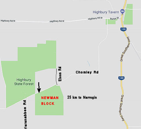
Newman Block (or part Highbury B to give its updated (yawn) name) is one of the reserves south-west of Highbury that come under Dryandra Woodland administration. This block is quite different from the ones north of Narrogin for a number of reasons.
The reserve (24km SW of Narrogin) is basically a granite hill that slopes to the north, south and west from the centre of the eastern boundary. It is situated relatively near the main flat valley of the ancient upper Arthur River in an area dominated by granite bedrock, without large dolerite dykes that underlie steep stony laterite mesas (as seen at Candy Block and Foxes Lair). The coarse-grained granite solidified slowly kilometres underneath the original land surface. Over hundreds of millions of years overlying rock has been eroded and washed away to form a low undulating landscape with relatively shallow sandy soils and lots of salinity in the waterways. Great wildflower country and few powderbarks.
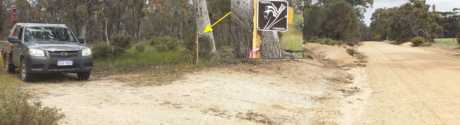
Enter by a nondescript track off Chomley Road near the western end of the reserve. Look for the small sign on a steel post.
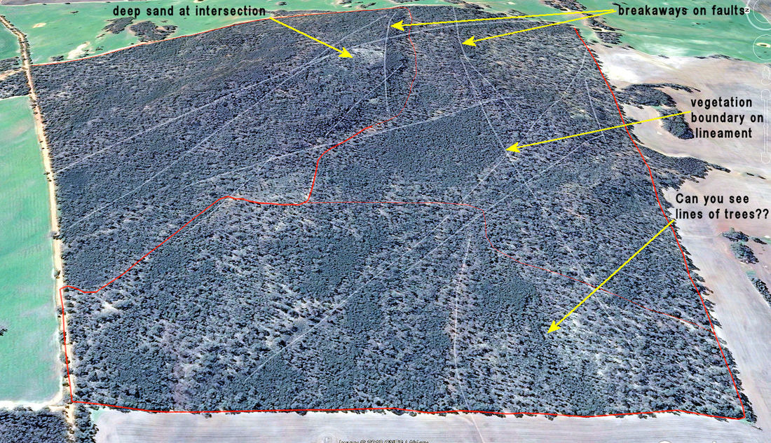
There is lots of variation in this reserve with distinct patterns and sudden changes of vegetation. Many linear boundaries define breakaways, ridges, changes of slope and vegetation edges.
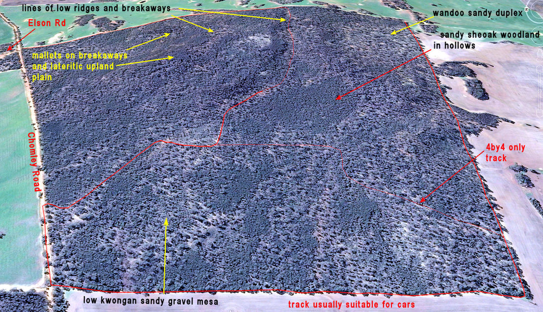
It took me days of walking to work out that the lines overlie geological lineaments. These are curved or linear, often raised lines over faults or boundaries of underlying granite types that were cooked and hardened when they were emplaced.Some of these can be seen as lines snaking across surrounding paddocks. There must be dozens, but I have drawn just a few below. I feel as though I have just scratched the surface of this reserve (get the pun?), and keep returning to learn more. A lesser (or saner) person would have stopped long ago but there is something addictive about following the bones of the landscape and making new discoveries
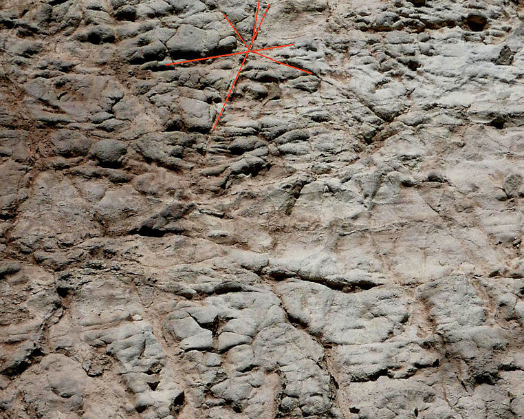
A patch of pallid weathered rock on a breakaway fault zone shows the enormous forces that acted here billions of years ago. The red lines indicated the directions of sideways forces on the rock that pulverised it into small segments as shown on the left.
If you find this patch, be thankful for the sweat I lost while furiously sweeping with a bannister brush for the photo, and evading insects racing around including a large disgruntled tick.
.
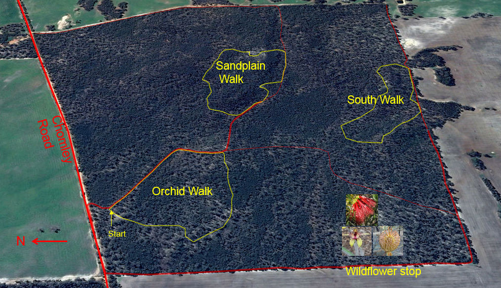
There are few vehcle tracks in this reserve. Many are not suitable for a family car at the moment, but hopefully,Parks and Wildlife Service will grade ones that lead to the best visiting spots (see maps) as walking track are created. The eastern boundary track is particularly rough. Of the three walk trails, The Orchid Walk and Sandplain Walk are ready for visitors.
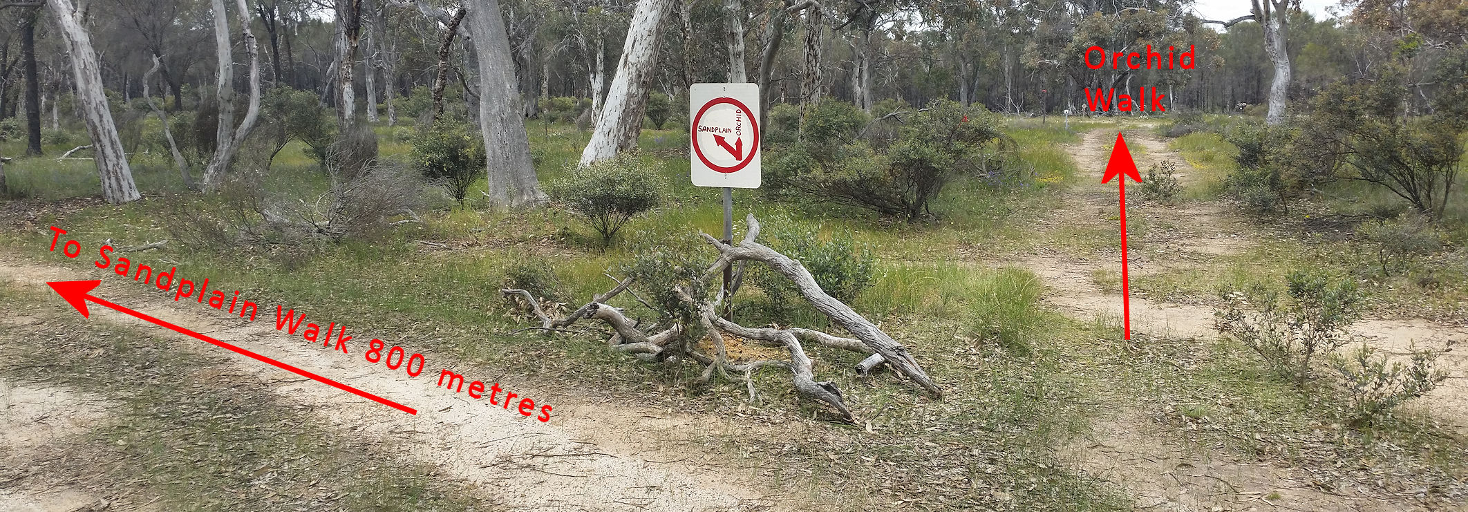
The Orchid Walk is delightful in September/ October. The 1.5 km grade 2 trail (gentle slope, easy walking, raked but unformed) leads through open woodland surrounding a very low (1 to 2 metre) sandy gravel mini-mesa (on your left). To avoid getting lost park where the track forks Soon after entering the reserve from Chomley road take the right fork and park at the clearing a few metres on to the left. Keep your eye out for occasional Chapman Spider and Dancing Spider orchids on the right near the start, and Bird Orchids on the lower slope of the tiny breakaway on the road near the end of the walk.
There are many orchids, cat paws, and lots of colourful low shrubs and everlastings that change as you pass successively through sheoak, wandoo, and marri woodland and kwongan scrub. A few visits are needed as flowering times vary.
There are many orchids, cat paws, and lots of colourful low shrubs and everlastings that change as you pass successively through sheoak, wandoo, and marri woodland and kwongan scrub. A few visits are needed as flowering times vary.

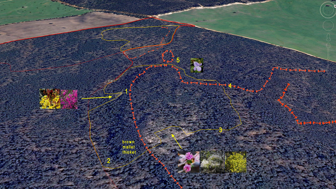
To get to the (approx. 2.5km) Sandplain Walk drive up the (rough) main track, taking care to veer left at the fork and stop at a raised mound of reddish soil on the right (see P sign. The complete walk is not for the casual happy snapper or infirm as it has a few steep spots and areas of rough dense bush if one deviates from the route. Having said that, it is a great walk with sudden changes in vegetation and great flower spots that vary in main flowering from August to December. Good to be alive country. The walk trail will first lead to a small granite outcrop surrounded by a mass of yellow Acacia celastrifolia flowers in August/Early September, and pinkish Mirbelia dilatata flowers and glowing red acacia new growth in October (1).
It then goes east on the gullied drive trail with the impressive fault-breakaway on the left through open wandoo and brown mallet woodland. It then turns left up a steep breakaway slope (2). At the top of the breakaway the landscape suddenly changes to a lovely sandy bowl fringed by stately jarrah trees. When I first saw this in early December it was a picture of pink-flowered Verticordia densiflora, yellow Calytrix flavescens and grey smokebush, but there is also Christmas tree and other sand-loving spring flowering species.
the trail crosses the sandy bowl then turns left (west) along a very low rise. (If you went straight ahead instead of turning left, you will go through a silver mallet/brown mallet plain before reaching a large rounded breakaway-take care as it is easy to get disorientated while walking over the frequent fallen mallets). Back to the walk; walk along left side of the open rise close to dense sandy vegetation on your left and brown mallet thicket on the right until you meet a brown mallet breakaway (4).
Go down the breakaway to relatively open ground and turn left with the breakaway on your left as you go through sheoak woodland until you see a break (5). Turn left and pass through the mallet woodland gap and down to the main track. Turn left and return to your car
The Newman south walk is not ready yet. To get there drive along the western edge of the reserve then around the southern side and park on the top of the first breakaway. There is a nice kwongan wildflower stop on the way with Banksia sphaerocarpa, Calothamnus quadrifidus, dancing spider orchids and other flowers.
The Newman south walk skirts around a valley lined by breakaways representing the convergence of several lineaments with numerous changes of slope and associated vegetation niches.
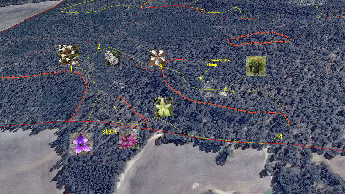
Drive along the southern boundary, up a breakaway slope and park at the base of the slope. Walk north along the narrow mesa. In October you will find purple enamel orchids and pink Chloanthes coccinea (mint family). As you cross a slight depression see the attractive view of farmland to the south (1). From here cross directly to the north (some interesting mallees here with intertwined painted marianthus creepers that makes a great show in Jan-Feb) and down the slope through a gap in the broombush to a granite rock that is just downslope of a saddle in the valley (2) to the right is an unusual winter-wet sedge slope with broombush on the right and a low rise (part mini breakaway) leading south-east on the left. Follow this rise that changes to brown mallet woodland with roadside tea tree in sandy soil to the left as it leads to the apex of a curved breakaway (3). Ascend the breakaway and veer right to the south where you will find a tangled thicket of Eucalyptus pachyloma (Kalgan plains mallee) that is a real picture in December at it and the intertwined painted marianthus are flowering. Skirt below the clump Christmas trees on deep sand and follow the breakaway until a break where it is easy to descend to the firebreak (4). As you walk back to the car, do a loop up the valley in Sept/early October and see if you can find a lutea form of the cowslip orchid
The Newman south walk skirts around a valley lined by breakaways representing the convergence of several lineaments with numerous changes of slope and associated vegetation niches.
Drive along the southern boundary, up a breakaway slope and park at the base of the slope. Walk north along the narrow mesa. In October you will find purple enamel orchids and pink Chloanthes coccinea (mint family). As you cross a slight depression see the attractive view of farmland to the south (1). From here cross directly to the north (some interesting mallees here with intertwined painted marianthus creepers that makes a great show in Jan-Feb) and down the slope through a gap in the broombush to a granite rock that is just downslope of a saddle in the valley (2) to the right is an unusual winter-wet sedge slope with broombush on the right and a low rise (part mini breakaway) leading south-east on the left. Follow this rise that changes to brown mallet woodland with roadside tea tree in sandy soil to the left as it leads to the apex of a curved breakaway (3). Ascend the breakaway and veer right to the south where you will find a tangled thicket of Eucalyptus pachyloma (Kalgan plains mallee) that is a real picture in December at it and the intertwined painted marianthus are flowering. Skirt below the clump Christmas trees on deep sand and follow the breakaway until a break where it is easy to descend to the firebreak (4). As you walk back to the car, do a loop up the valley in Sept/early October and see if you can find a lutea form of the cowslip orchid