 Granite formation during subduction
 Greetings fellow Foxies,
Some years ago, a visiting Scot remarked that our granite rocks looked old and tired compared with the ones at his homeland. I had to agree. Unlike Scotland, our Yilgarn craton bedrock has been stable for millions of years. No geologically recent volcanism or mountain building events. And best of all no haggis!
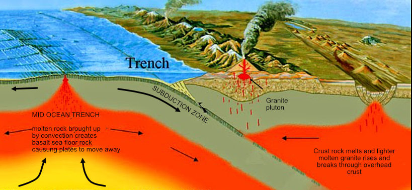
Granite forms when geological plates collide and one slips under the other (subduction, see this blog).
WA granites formed over 2 billion years ago
Over hundreds of millions of years, the top of our granite bedrock has been very slowly breaking down to soil that has been washed or blown away causing mountains to flatten.
About 300 million years ago the land was also ground down by glaciers. Overall, long term erosion has lowered the ground level by up to 5 km.
It is over this time that our granites have cracked and weathered (become tired).
The bedrock has been fractured many times as the craton has been shunted around during supercontinent cycles. Intact solid rock outcrops like Yilliminning rock less frequent. Most granite outcrops have horizontal and vertical cracks (called joints) that weather to large boulder heaps and cracked rock outcrops.
Some years ago, a visiting Scot remarked that our granite rocks looked old and tired compared with the ones at his homeland. I had to agree. Unlike Scotland, our Yilgarn craton bedrock has been stable for millions of years. No geologically recent volcanism or mountain building events. And best of all no haggis!
Granite forms when geological plates collide and one slips under the other (subduction, see this blog).
WA granites formed over 2 billion years ago
Over hundreds of millions of years, the top of our granite bedrock has been very slowly breaking down to soil that has been washed or blown away causing mountains to flatten.
About 300 million years ago the land was also ground down by glaciers. Overall, long term erosion has lowered the ground level by up to 5 km.
It is over this time that our granites have cracked and weathered (become tired).
The bedrock has been fractured many times as the craton has been shunted around during supercontinent cycles. Intact solid rock outcrops like Yilliminning rock less frequent. Most granite outcrops have horizontal and vertical cracks (called joints) that weather to large boulder heaps and cracked rock outcrops.
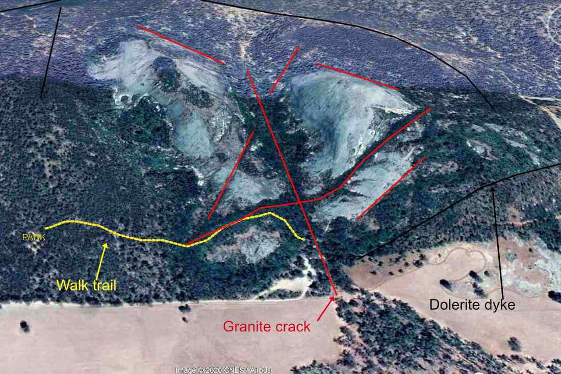 Aerial view of Boyagin Rock | 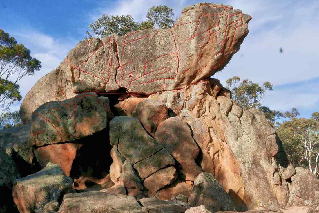 Highlighted cracks on Lizard Rock |
 Cracks in a 2 metre square area of exposed pallid clay on a ridge
 The vertical joints are obvious on an aerial photo, as ridges and valleys that often trend east/west, northeast/ southwest, north/south or northwest/southeast, and make right angle turns.
Locally, the most obvious area is southwest of Narrogin, where much of the old laterite cover has been removed and soil has formed on basement rock.
Newman Block is a great example. Lines of vegetation reflect changes in the granite ‘grain’ as well as faults and dykes. The image on the left of pallid zone clay on a ridge displays an amazing number of joints that are in the underlying bedrock.
Eager to learn why the joints follow particular directions I started reading on and on and on…… It is a long and fascinating story.
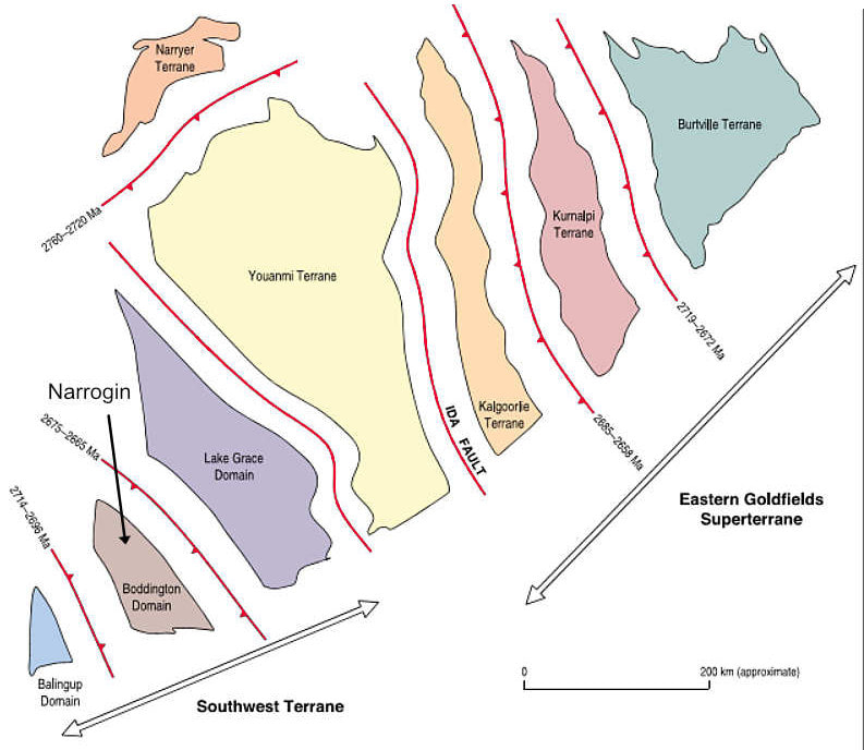
Our local bedrock has a northwest/southeast trend or ‘grain’ from the formation of the Yilgarn Craton as ‘islands’ of continental rock collided about 2.8 billion years ago. The red lines between the domaines/ and terranes show subduction zones where one slid under the other as they collided. These zones are called orogens.
The orogens on the north, northeast and southwest sides formed when the Yilgarn Craton collided with other land masses as the Australian continent was being built up. The Pinjarra orogen on the west side has had at least three collisions with other land masses including the Zimbabwe craton and India.
The orogens on the north, northeast and southwest sides formed when the Yilgarn Craton collided with other land masses as the Australian continent was being built up. The Pinjarra orogen on the west side has had at least three collisions with other land masses including the Zimbabwe craton and India.
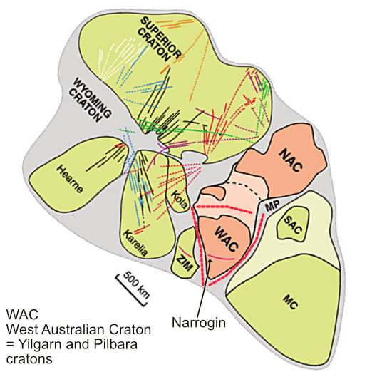
 Assembly of the Yilgarn Craton from southwest to northeast | 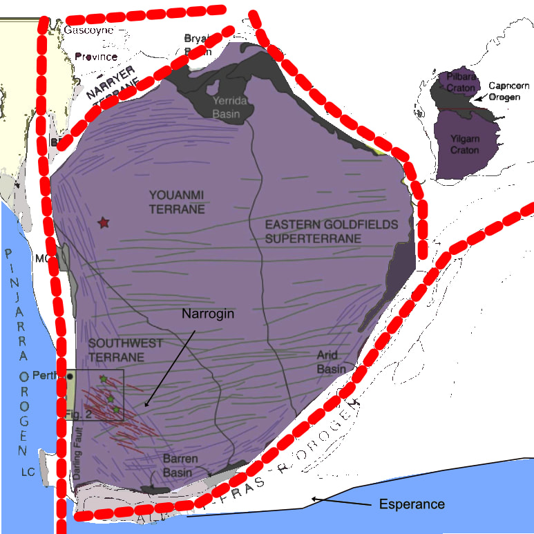 Red lines are orogens where Yilgarn Craton has collided with other land masses |
During this time, the craton has joined and separated from at least three supercontinents as it has drifted over the globe.
The images below show the position the WA in three supercontinents before they split apart. I have taken the liberty of rotating the supercontinents so that WA is in its present north/south orientation.
The radiating multi-coloured lines on the Nuna supercontinent are joints caused by pressure from mantle hotspots that have filled with intrusive rock to form dykes (see this blog). These also affect the direction of joints in continental rocks.
 Nuna about 1.4 billion years ago | 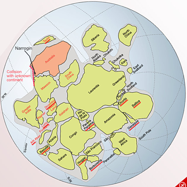 Rodinia 750 million years ago | 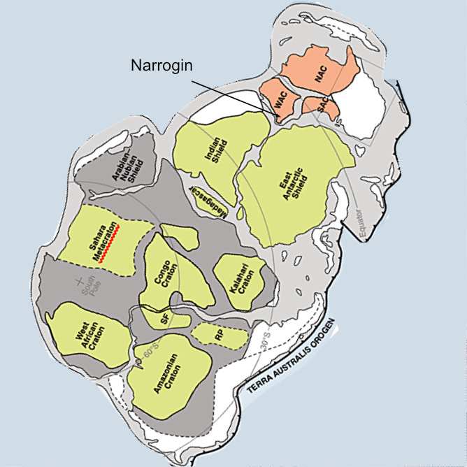 Gondwana 520 million years ago |
When India and Antarctica separated from WA, reduction of weight from the combined continents on the underlying mantle created an upward pressure that caused the Darling Range to slowly rise on the west coast accompanied by parallel faults inland. On the south coast a line of uplift parallel to the coast (Jarrahwood Axis) caused east/west trending faults and formerly south flowing rivers to reverse flow and eventually join the Swan River. On the south side of this uplift the coast slumped forming a slope down to the ocean.
The Australian plate is inexorably drifting north and is subducting underneath the Eurasian Plate. In a couple of hundred million years Darwin could be a suburb underneath Bali, or possibly a ski resort!
This subduction is extremely slowly causing the Northern Australian coastline to sink, and the south coastline to rise (unfortunately not as fast a sea level rise from climate warming).
Stress from tilting of the Australian Plate is a cause of earthquakes like the Meckering quake.
It is no wonder that our granites look old and tired. Still they create interesting shapes and landscapes.